Here the ancient hard rocks of the Canadian Shield to the north abruptly meet the softer limestones of the ancient seas creating a stark contrast in landscapes, ecosystems, and a diverse cultural history unique in North America. First Nation communities begin growing maize in the fertile soils of Ice Age glacial sediments at least 4000 years ago. French missionaries and explorers arrived in the early 1600s, followed by British settlers after 1840 drawn by agriculture, fishing and lumber.
You are here
Indigenous place-based narratives for DEEP TIME ZONE 7 are being developed in concert with Indigenous-owned creative agency Design de Plume, regional Knowledge Keepers and Georgian Bay Indigenous community representatives. To find out more or provide input please contact us.
The Attignawantan (people of the bear), Attigneenongnahac (people of the cord), Arendahronon (people of the rock), and Tahontaenrat (people of the deer) were the main Huron-Wendat confederacy members. The Bear, Cord, Deer, and Rock reliefs were sculpted in clay, cast in bronze, and set on local gneiss stones by Canadian sculptor Tyler Fauvelle, who was inspired by the country's natural and cultural history. A circle – a significant cultural symbol as the earth, the sun, the moon, and numerous natural cycles are all represented by circles – forms the arrangement of the reliefs and additional border limestones. Numerous Indigenous spiritual traditions use the number four, and the artist uses the four elements of wind, water, earth, and fire in the reliefs. The full moon and the Great Turtle are among the symbols from the Huron-Wendat creation legends that are embraced in the artwork.
The forested sand dunes in Wasaga Beach Provincial Park are indeed the largest dunes in the Georgian Bay area. However, they have been inactive for approximately 2000 years. Around 6000 years ago, a large sand spit formed across the entrance to Nottawasaga Bay. Over time, lowering lake levels and a drier climate allowed this sand spit to serve as a continuous source of sand for the dunes, which began blowing southeastward away from the lake. By 2000 years ago, the climate became wetter, leading to the vegetation and stabilization of the dunes. As a result, they have remained relatively unchanged since then.
Tiny Marsh is a Provincial Wildlife Area and was Ontario's first provincially owned and managed wetland, serving as a vital habitat for numerous bird species and other wildlife. Its recognition as an Important Bird Area (IBA) underscores its ecological significance, making it a cherished destination for birdwatchers and a crucial site for biodiversity conservation.
The coastline at Awenda is awash with 'erratic' boulders. These 'wanderer rocks' have journeyed far from their origins in the Canadian Shield. Subjected to high wave energies at he head of the Penetang Peninsula, many have been worn into interesting shapes as the original gneissic textures erode differentially.
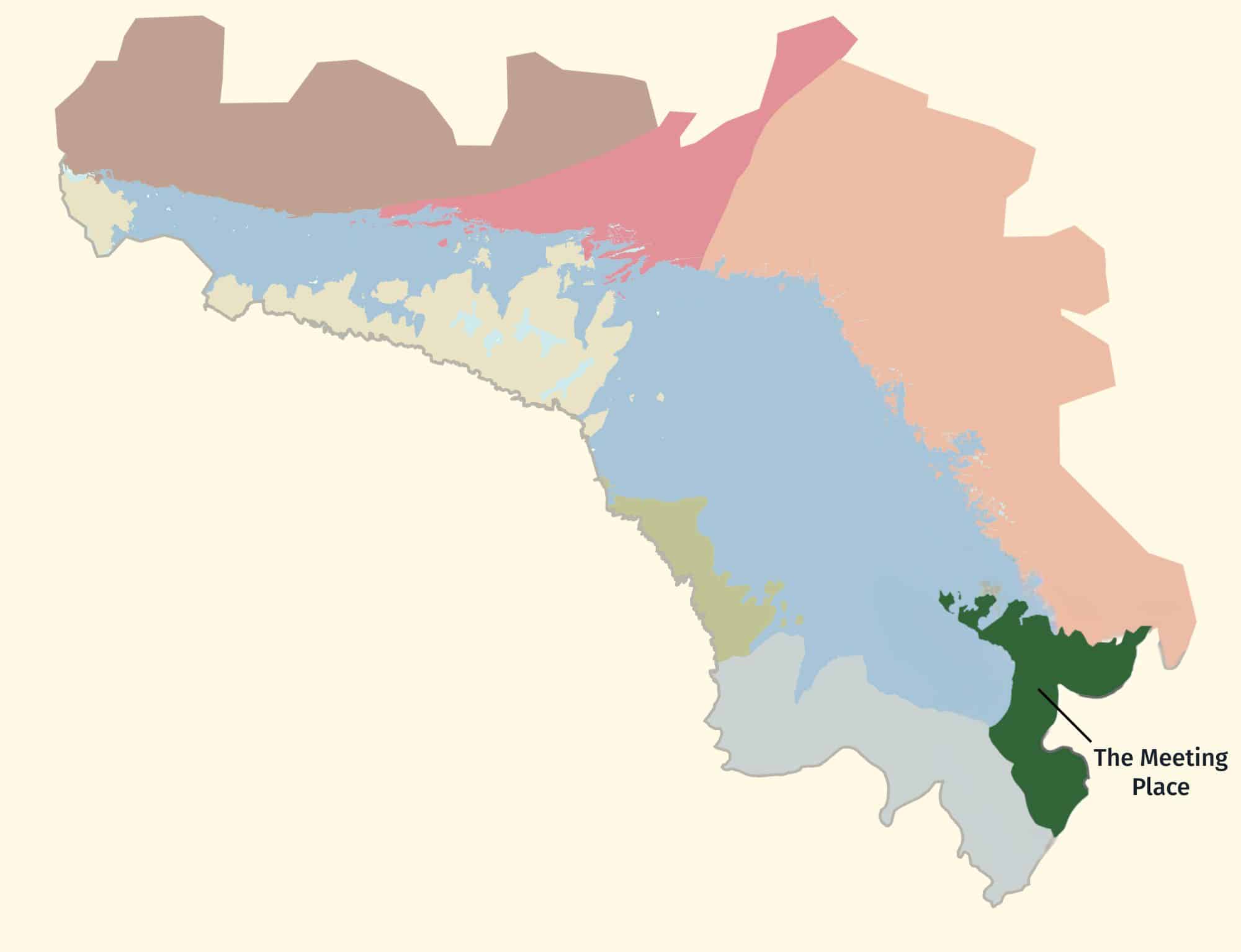
Beausoleil Island is located in Georgian Bay Islands National Park, the smallest national park in Canada at only 13.5 sq km. However, it boasts a unique geological composition, straddling two natural georegions. The island transitions from windswept pines and Canadian Shield in the north to dense woodland forest in the south, showcasing a diverse range of natural landscapes. Much of the island is mantled by nearshore deposits of post-Algonquin lakes in which a well over 10 m thickness of nearshore sands and gravels were deposited. Beausoleil Island holds significant historical importance, with evidence of human occupation dating back over 7,000 years. Archaeological findings, including ancient pottery, tools, and hunting implements, suggest the island was used as a summer camp by early hunting and gathering cultures, including the Algonkian-speaking Odawa during the Late Woodland Period
At one time, Penetanguishene and its excellent harbour was the only European settlement on Georgian Bay and was noted by Governor John Simcoe in 1794 as a potential location for a naval base to control the Upper Great Lakes. Unused in the war of 1812, it was not until 1828, that the British Garrison on Drummond Island then ceded to the US by the Treaty of Ghent in 1814 which restored the border between the two countries to that before the war started, relocated to Penetang. The garrison was accompanied by many French Canadian voyageurs and Métis fur traders who had worked for the British military. In this way, the unique bi-cultural makeup of the area was established and persists to this day. For a time the small community was the main entry point for settlers en route to Georgian Bay. The arrival of the Midland Railway of Canada at Mundy’s Bay (re-named as Midland) bypassed Penetanguishene as a port and the naval base closed in 1856. The town of ‘Penetang’ is built on the staircase-like terraces left by glacial Lake Algonquin 11,000 years ago.
The reconstructed 17th-century village of Sainte-Marie among the Hurons was the western terminus of the early fur trade. The original village, part of which was made of limestone from Ontario's first quarry, was burned in 1649 by missionaries before they abandoned it to invading Iroquois warriors.
For learning, curriculum, and digital storytelling to be guided by community input.


LIDAR (Light Detection And Ranging) is a remote sensing method that uses light in the form of a pulsed laser to measure variable distances to the Earth. LIDAR mapping tells us the geological stories of the past and informs geologists and others about what may happen around the world as it ages. LIDAR also reveals changes in the land vegetation that may inform affects of climate change. These are sample LIDAR mappings of some of the well known regions and locations of Deep Time Zone 7.
DEEP TIME’ is the themed expression of how exploring and understanding the past helps create a better future. The unique DEEP TIME story and its eight geological chapters encourages both visitors and residents to know the past, celebrate the present and help create a more resilient future for the Bay and its many communities.
2.7 billion years
Sault Ste Marie to Serpent River
The ancient mineral-rich rocks of the North Channel record the breakup of the planet’s oldest supercontinent – and the birth of the Huronian Ocean.
1.8 billion years
Serpent River to Killarney
The Group of Seven’s white rolling quartzite hills are the stumps of mountains formed when landmasses collided to form supercontinent Nuna
1.3 billion years
Killarney to Honey Harbour
The waterscape of the 30,000 Islands exposes the deep crustal roots of the immense Grenville Mountains formed when North and South America collided.
500 million years
Manitoulin Island
Much of North America was covered by warm shallow seas, teeming with early marine life that left fossil-rich limestones on Manitoulin Island.
350 million years
Tobermory to Wiarton
Within the last 2 million years, the Bruce/Saugeen peninsula was scoured by Ice Age ice sheets that cut deep valleys into the face of the Niagara Escarpment such as at Owen Sound.
13,000 years
Collingwood to Wiarton
The raised beaches of glacial Lake Algonquin surround the coast of southern Georgian Bay like staircases and hosted the camps of caribou-hunting Paleo-Indians 11,000 years ago.
4,000 years to today
Waters of Georgian Bay
In 1615 Samuel de Champlain called Georgian Bay ‘La Mer Douce’ (the sweet water sea). An early map also portrays it as Karegnondi, derived from ‘lake’ in the language of the Petun First Nation.


