Aerial view of serene water landscape.

News & Events

Stories of Deep Time

November 20, 2023

Mapping Georgian Bays Environmental and Geo Cultural Landscape
By Dr. Kirsten Kennedy, University of Toronto, Scarborough

This summer, our team from the University of Toronto Scarborough completed fieldwork investigating the environmental and geocultural landscape of Georgian Bay. The landscape as we know it comes about as a result of the interaction between bedrock geology and the environmental processes that have operated upon it within a changing climate. We visited sites across Georgian Bay to learn more about those processes and how people have interacted and continue to interact with this changing landscape.

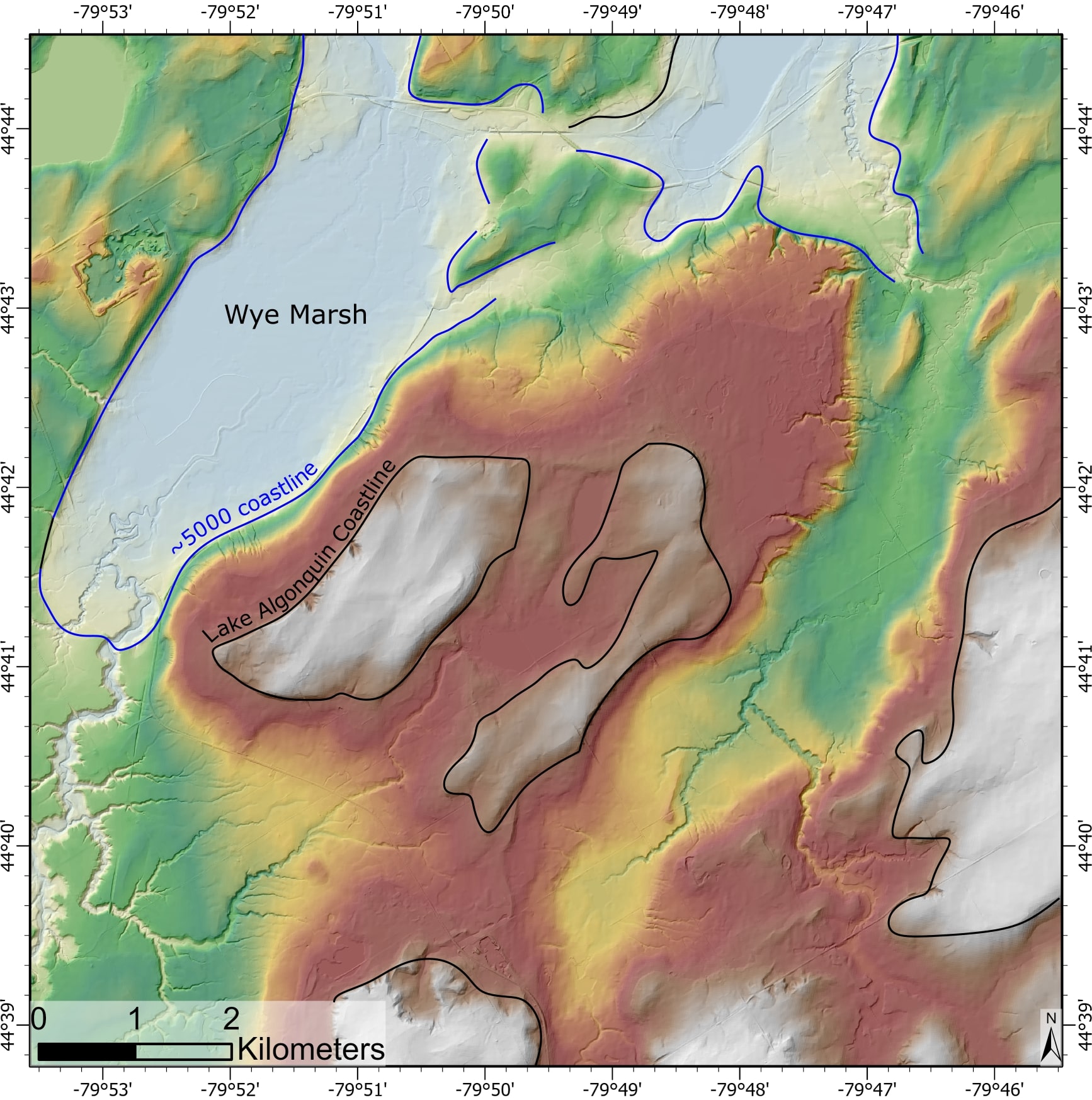
In ‘Huronia’ – the region roughly between the Nottawasaga and Severn Rivers – we worked with Jamie Hunter to explore the ancestral home of the Wendat. One tool at our disposal is called ‘LiDAR’ which uses pulses of light to collect very high resolution elevation data. The geomorphology of Huronia today consists of plateaus separated by valleys. Many of these plateaus were once islands in a vast glacial lake that formed about 11,000 years ago against the margin of the last ice sheet. As the waters receded (and later rose and fell again) it left behind fossilized shorefaces and bluffs, much like the rings in a bathtub, which can be visualized with LiDAR.


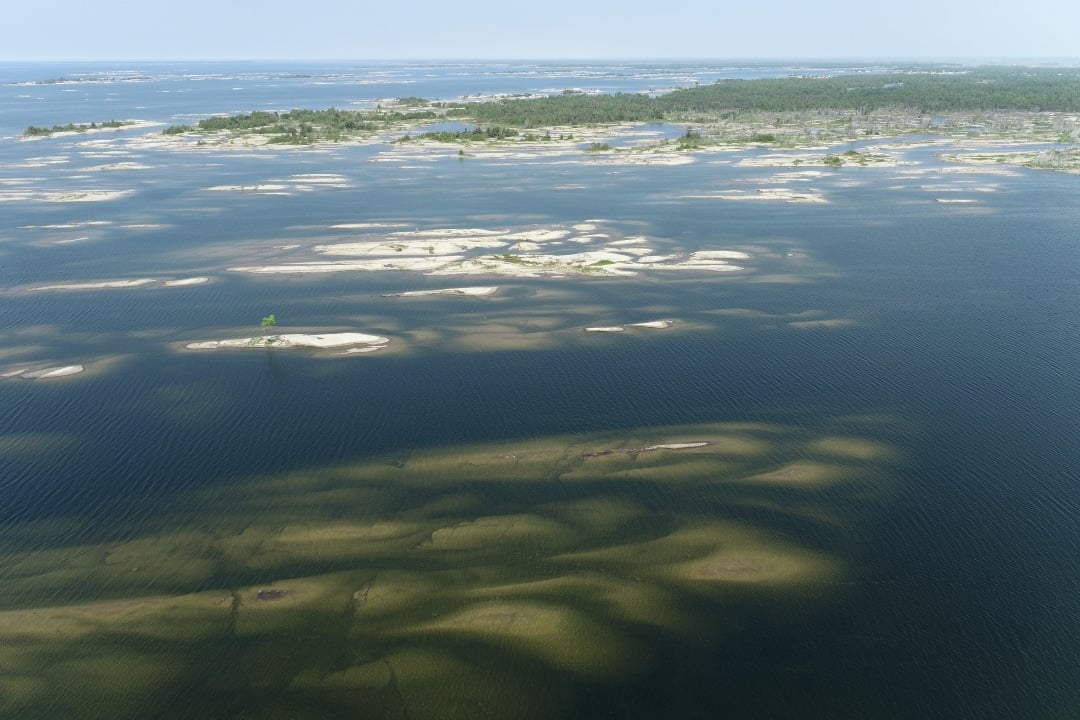
A very different type of landscape with thousands of low-lying islands on the north shore of Georgian Bay was the focus of another leg of field work. Data collection between Key Harbour and Byng Inlet revealed the influence of deep glacial scraping that cut grooves in the gneissic bedrock 14,000 years ago. The grooves cluster together to resemble pods of diving whales with their backs poking out of the water. These ‘outboard’ islands shelter the intricate network of waterways which have been used for millennia.

Make a gift to our geology work and more Georgian Bay Geopark work online https://georgianbaygeopark.com/donate/

Discover the DEEP TIME geology of the Georgian Bay Geopark

DEEP TIME’ is the themed expression of how exploring and understanding the past helps create a better future. The unique DEEP TIME story and its eight geological chapters encourages both visitors and residents to know the past, celebrate the present and help create a more resilient future for the Bay and its many communities.

DEEP TIME Zone 1

The Huronian
Ocean

2.7 billion years
Sault Ste Marie to Serpent River

The ancient mineral-rich rocks of the North Channel record the breakup of the planet’s oldest supercontinent – and the birth of the Huronian Ocean.

DEEP TIME Zone 2

Continents
Collide

1.8 billion years
Serpent River to Killarney

The Group of Seven’s white rolling quartzite hills are the stumps of mountains formed when landmasses collided to form supercontinent Nuna

DEEP TIME Zone 3

The Ancient
Himalayas

1.3 billion years
Killarney to Honey Harbour

The waterscape of the 30,000 Islands exposes the deep crustal roots of the immense Grenville Mountains formed when North and South America collided.

DEEP TIME Zone 4

Tropical
Seas

500 million years
Manitoulin Island

Much of North America was covered by warm shallow seas, teeming with early marine life that left fossil-rich limestones on Manitoulin Island.

DEEP TIME Zone 5

The Limestone
Coast

350 million years
Tobermory to Wiarton

Within the last 2 million years, the Bruce/Saugeen peninsula was scoured by Ice Age ice sheets that cut deep valleys into the face of the Niagara Escarpment such as at Owen Sound.

DEEP TIME Zone 6

Ice Ages &
Early Cultures

13,000 years
Collingwood to Wiarton

The raised beaches of glacial Lake Algonquin surround the coast of southern Georgian Bay like staircases and hosted the camps of caribou-hunting Paleo-Indians 11,000 years ago.

DEEP TIME Zone 7

The Meeting
Place

Last 10,000 years
Collingwood to Honey Harbour

The ancient hard rocks of the Canadian Shield meet the softer limestones of the ancient seas creating a stark contrast in landscapes, ecosystems, and a diverse cultural history unique in North America.

DEEP TIME Zone 8

Mindo Gami Great
Spirit Lake

4,000 years to today
Waters of Georgian Bay

In 1615 Samuel de Champlain called Georgian Bay ‘La Mer Douce’ (the sweet water sea). An early map also portrays it as Karegnondi, derived from ‘lake’ in the language of the Petun First Nation.

Sign Up For Our Newsletter